MENU
Mobile menu goes here!
SIGN IN

Invalid username or password.

Forgot Username or Password?

If you do not remember your username or password, the system can send them to you. Please provide the email address you registered with.

Error: Please check your email address and try again.

100-, 125-, 150-Mile Route

Download 100-, 125-, 150-Mile Route Sheet (Excel)

Uploading Routes to GPS Devices

We know many of our riders are interested in being able to upload our route(s) onto compatible GPS devices and we want to make that ability a smooth experience. As a way to do that we have created our maps on the STRAVA website for consistency with our King / Queen of the Hill challenges. If your device can export or record your activities in GPX, TCX, or FIT format, and these files contain actual workout data, your device is compatible with Strava. If you don’t have a current STRAVA account, don’t worry - it's FREE!
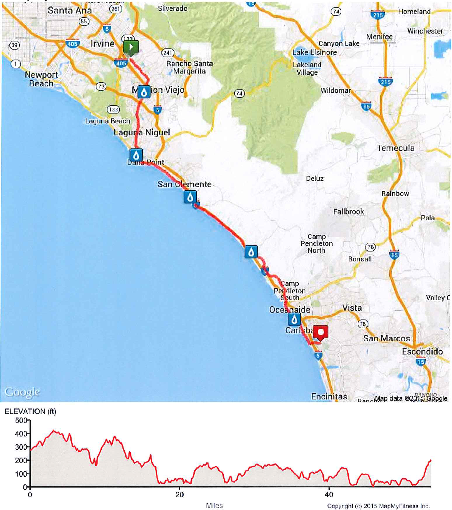
Day 1, 50-Mile Riders

You'll start with 2000 other cyclists from the Irvine Transportation Center, then head for the coast through Lake Forest, Mission Viejo and Laguna Niguel. At Monarch Beach you'll begin riding on the Coast Highway, through Dana Point and past its picturesque harbor and Doheny State Beach.

Leaving the highway, you'll wind your way through the community of San Clemente before passing San Onofre power plant and State Beach. Enjoy the solitude of biking through Camp Pendleton Marine Base, the largest undeveloped section of coast left in Southern California. Leaving the Marines, you'll go back to hugging the coastline in Oceanside, where you'll pass its harbor and pier. Finally, you'll pedal through the village of Carlsbad before turning inland and gaining a little elevation to reach the finish line at the Carlsbad Sheraton, where a party with food, friends, and a spectacular view await.

Day 1 50-Mile Route Map and Elevation Profile

Day 1, Century and (new for this year!) 75-Mile Riders

Stronger riders who want more miles follow the first 50 miles, but continue down the coast through Carlsbad and turn inland at Batiquitos Lagoon. After the relatively flat ride along the coast, riders climb 700ft to San Elijo. The 75-mile route then goes back downhill, returning to the coast through La Costa.

From La Costa, the Century route continues to climb another 600 ft over the shoulder of Double Peak before a screaming descent past Cal State San Marcos.

From there it is back to the coast, via the Del Dios highway high above Lake Hodges and through Rancho Santa Fe before rejoining the Coast Highway in Solana Beach. On the home stretch now, it's back north to Carlsbad before your well-deserved party at the finish line.

Century:

Day 1 Century Route Map and Elevation Profile

See Day 1, 50-mile route above for first 50 miles of this distance.


75-Mile:

Day 1 75-Mile Route Map and Elevation Profile

See Day 1, 50-mile route above for first 50 miles of this distance.

Day 2, 50-Mile Riders

Following a hearty breakfast at the host hotel, riders will explore the village of Carlsbad and Buena Vista Lagoon before returning to the Coast Highway and heading south. (An “Express Route” that cuts off Carlsbad and 10 miles is also an option by just heading straight south on the Coast Highway.) Count the surf shops and yoga studios as you pedal through the iconic beach-side communities of Leucadia, Encinitas, Solana Beach and Del Mar. Then it's up Torrey Pines hill and past the San Diego campus of the University of California before dropping down into La Jolla, the Jewel by the Sea. Continuing south along the coast, you turn inland at Pacific Beach to go around Mission Bay to arrive at the finish line and party at Hospitality Point.

Day 2 50-Mile Route Map and Elevation Profile


Thank you to our premier national sponsors

Become a Sponsor
 

Live Events


Please check back as events are added regularly!